Jotunheimstien for Dummies
The official Web site at www.jotunheimstien.no leaves a lot to be desired when it comes to useful information for potential hikers. I've tried to gather some of it on this page instead.
Buying Food Along the Way
The trail goes through wilderness as much as possible, and when you finally reach the cabins where supplies can be bought, you've almost completed the hike! This leaves just a few places where you can buy food and other supplies when you're on the trail. Here they are, from south to north:
- After 3-5 days of walking, you cross road number 4 at Lygnasæter. There you'll find a hotel with all facilities, including a restaurant. There's also a petrol station that is always open, where they have a good selection of groceries.
- When the trail comes down from the mountain Kvitingen, you're less than an hour of walking away from the village Eina, where there's a grocery store and a petrol station with normal opening hours.
- In Snertingdalen you cross a main road where there's a small grocery store, open from 9-17 on weekdays.
At Kittilbu there's a small museum where you can buy waffles, cold drinks and possibly traditional meals like porridge between 11 and 16 every day during the summer.
- Liomseter is a hotel-like large, old farm house, where you can have warm showers and buy cold drinks, snacks and light meals in the evenings.
- Sikkilsdalen is a very nice mountain lodge. They sell various drinks, as well as some food that is caught and prepared right there.
I recommend carrying cash to pay for what you need, just in case there's a problem with paying by plastic.
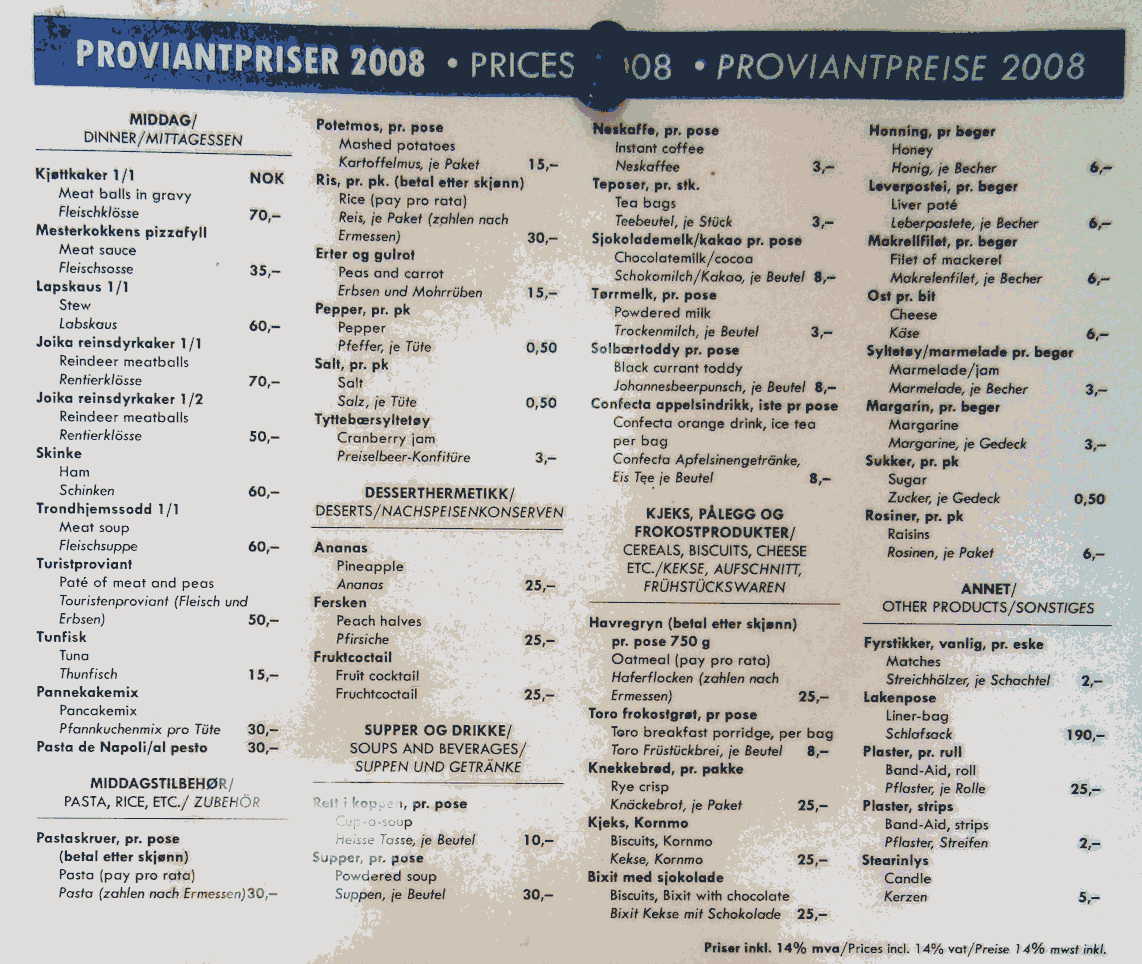
That's it! In addition to this, the Hikers Association has cabins at Storkvelvbua, Storhøliseter and Oskampen where basic supplies can be picked up and paid for later when you arrive back in the civilization. Here's a list of what you can typically find and at what prices.
Accommodation
For the first two thirds of the trail, the open cabins are located far apart, so unless your pace of walking fits the suggested itinerary completely, you had better carry a tent. I found a few great places to pitch my tent away from the cabins, where there was both flat ground and water available for drinking and washing. Here they are:
- A looong day's walk from the start: A small headland by the southern end of the Storøyungen lake here. Nearby there's a dam where good water exits the lake into a small stream. NB! When I was there the place teemed with midges/no-see-ums that were hungry for human blood. If you can't get here, there's a small pond just above Hakadal a couple of hours closer to Oslo (an hour after you pass by a golf course) where there's a table and flat land.
- Just next to the Hikers Association's cabin at Snellingen good camping can be found, here. The water in the well is delicious. Warning: Sometimes there will be insane amounts of sheep droppings there.
- Near the middle of the northern side of the lake Vassbråa there's a small beach, and just above it there's a nice patch of grass where you camp, here. On a warm summer night you may be joined by locals going for a late and probably noisy swim, but otherwise it's a great spot. There's water in streams both to the east and to the west of this site.
Before you start climbing Kvitingen, there's a decent place for camping by lake Gulsjøen, here. When you come to some cabins and the trail leaves the lake, follow the side road leading down to the lake instead. Walk past a small boathouse and continue 50 or so metres until you find nice and flat forest by the lake. I couldn't find any drinking water here (apart from in the lake), but fortunately I had filled my bottles down in the valley, just after passing the railway tracks of the Gjøvikbanen line.
- If it fits your schedule, a cabin belonging to Toten Almenning by Skjersjøen seemed like an excellent place to spend the night, here. It's open for anyone. I continued walking almost to Vesterås. Instead of staying there I walked a few hundred metres west off the trail by lake Elgsjøen, here. There I found flat ground and a nice spot with a table and a small roof to sleep under.
- After the Lundon/Brattengshovde area just before Snertingdalen there's a small pond called Lunken, here. At the eastern end of it there's a small, rocky headland where you can pitch a tent. The surrounding area is wet marshland, so you may have to search a bit for this place. There's good water nearby, exiting the pond.
- The cabin Skjellbreidhytta also seemed like a nice place to spend a night, and there's also a good camp site just before it, down by a bridge across a small, but busy stream. I kept walking across Skjellbreida mountain to a small lake near Nyseter, here. Climb over a fence onto the grazing land and walk up onto the rocky hill by the lake, opposite the small farm there. It looks muddy and bumpy, but close to the water there's a flat area. Get water from one of the streams you pass just before you reach the lake and climb the fence.
- Just above the Hikers Association's buildings at Liomseter they will let you camp. You'll have a great sleep there after having enjoyed what is probably your first hot shower on this trail!
- It is possible to pitch a tent at Storhøliseter, but only if you bring a very, very mosquito-proof tent. This place is where the myth of Dracula must have been born! There's water inside the cabin there.
- You can pitch your tent outside the lodge at Sikkilsdalseter, but you can also enjoy the novelty of sleeping in a bed at a fairly low price inside there, roughly 300 kroner, which includes as many and as long-lasting hot showers as you like.
Finding the Trail
I walked the trail without a proper map, and I had few problems with that. Some places were more difficult than others, though:
- The entire leg across Kvitingen mountain between Gulsjøen lake and Eina was poorly marked. It almost looked as if the trail had been sabotaged by someone. Maybe someone wants their cloudberries for him- or herself? Some places the blue paint had been scratched off trees, other places whole trees with markings had been felled. Also, much of this area is wetlands, so losing the trail here can cost you a lot of time and energy. On the top of Kvitingen the trail is difficult to figure out. When you come from the south and follow the trail to the top, do enjoy the view. However, when you want to continue your hike, you have to backtrack a few metres and make a ninety degrees turn down a hill and straight into the marshland. And then there's another bit of wetland, and another one, and ten more. It's easy to let the trail disappear here, so take your time and make sure you're on the trail all the time here. Do not just assume that the trail is following a general direction all the time.
- Between Korperuddalen valley and the Venholhøgda hills I found three signs where the Jotunheimen Trail was shown both in the northernly and southernly directions. However, the signs had been pulled out of the ground and turned around, so that you would completely go in the wrong direction if you followed the signs. I fixed all three of them, but pay attention here, just in case there's a crazy person in the area doing this for fun every now and then.
- When you approach the Storhølipiggen mountain from the south, there are to alternative trails to follow to get to Storhøliseter. One trail looks like hard walking, as it climbs a mountain pass, while the other one looks like an easy and pleasant walk through the forest around the mountain. Pick the pass! The forest is mosquito-land, and I regretted having chosen to walk through it.
Public Transportation To and From the Trail
Because the trail goes through uninhabited areas, there are few places where you can easily break off your hike if you need to. These are the only options I found:
- You can get on a bus to and from Lygnasæter Hotell.
- An hour of walking east (5 kilometres) off the trail, there's a railway station, Eina jernbanestasjon, where all trains on the Gjøvikbanen line stops. A little bit closer to Oslo, some trains also stop at Bleiken station just one kilometre off the trail. Also nearby, there are buses to Oslo from Brandbu.
- After Vesterås you can walk to Tobru, where there's a bus stop, or you can follow the trail to another bus stop at Mustad. Just after this you follow the Sevalsvegen for a couple of kilometres, where there are a few buses to Gjøvik.
- The grocery store in Snertingdalen is also a bus stop, but few buses go there. The buses go to and from Gjøvik.
This one requires a bit of walking off the trail, but if you walk to the north-east instead of north-west from the Skjellbreidhytta cabin, you get to Forset instead of to Kittilbu. From Forset there's one or two daily buses to Lillehammer. To get to here from Lillehammer, you'll have to get on the bus in Lillehammer at 6:40 in the morning...
- After Kittilbu there is no public transportation at all until you reach Gjendesheim, the end of the Jotunheimen trail. From Gjendesheim there are buses ("Valdresekspressen) leaving for Oslo in the summertime, at around 3 and 5 in the afternoon. With a bit of luck I suppose there are good chances for hitching rides with others from Liomseter and Sikkilsdalen, as they get quite a few visitors during the day.
Anything Else?
Do ask me any other questions you may have regarding the Jotunheimen Trail. I'll add important details on this page as I discover what you guys need to know!
Happy trails!
Bjørn
|